User-friendly data management
We know you don't want to spend all your time managing data. That's why Civillo's administrative functionality is just as simple as its user functionality.
Hassle-free layer uploads
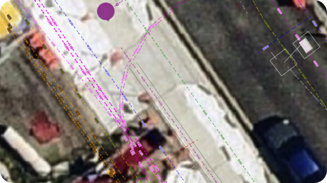
Data uploaded to Civillo retains native linestyles, colours, attributes, layering, and other metadata from the original source file.
Uploading layers to Civillo is intuitive and seamless, with no requirements for files to conform to a specific schema or standard.
Data uploaded to Civillo retains native linestyles, colours, attributes, layering, and other metadata from the original source file.
Civillo natively converts coordinates of incoming files, so all your data is aligned to your project datum. Simply select the coordinate system of your file upon uploading, and Civillo will do the rest.
Set your project to known coordinate datums, or apply a custom coordinate system to your localized project site
Supported File Formats
Share your data with collaborative tools
When collaboration is required, use Civillo to share data inside or outside the platform.
- Make layers available to your team, partners, sub-contractors, and clients.
- Set granular permissions for individual users, or define user groups.
- Actively share markups, work orders, permits, and more inside Civillo.

Project Links - A unique way to share data
Tired of the old, inefficient ways of sharing data?
Create a direct data link with another Civillo project, inside or outside your organisation, and say goodbye to the hassles of email or cloud drive download links.
Provide full transparency to an interfacing project with real-time, automatic layer updates from the original project.
Integrate workflows using the Civillo API
Moving away from manual processes?
Leverage Civillo's API to automate layer uploads into Civillo and get data to your team faster. Set up an integrated workflow to create folder structures and assign layers to Civillo as they become available in your common data environment. Always have the latest designs, the most up-to-date utilities models, and most recent asbuilt layers in Civillo.